
Thank you for visiting RV Ramblings, the daily happenings of full-time RVers, James and J, as told by James.
You may share this particular blog entry by referring to www.rvramblings.com/?date=2010-10-20.
Visit www.rvramblings.com to view the latest blog entry. Click here to create a bookmark that will take you to the latest blog entry.
October 20, 2010, a Wednesday
near Capitol Reef National Park, Utah, USA
— Took the Notom-Bullfrog Road and Burr Trail Road
[You may view a map of Capitol Reef National Park in PDF format.]
We got up earlier than usual all excited to go explore the Cathedral Valley area in the northern part of Capitol Reef National Park. I made a mug of coffee to go and J started a mug of tea steeping, and we left in the Jeep around 7:05 before the approximately 7:35 official sunrise.
I had Clif Bars for breakfast while driving.
We went to the ford across the Fremont River, and the ground looked really muddy before we even got close enough to the river to see it. Neither of us wanted to get stuck, so we turned around and took the Notom-Bullfrog Road south along the eastern side of the park instead.
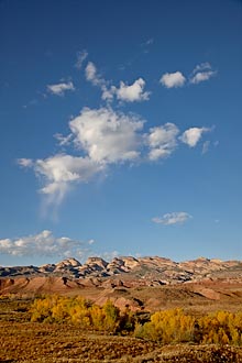 We stopped just a few miles down the Notom-Bullfrog Road to photograph sunrise with some nice rock formations to the west and some cottonwoods that were starting to turn yellow in the foreground. The clouds that had been above the formations dissipated before sunrise, but we decided to stick around because there were lots of clouds to the south. The formations developed a nice warm glow at first light, but without any clouds behind them they weren't too interesting photographically. We waited around for the sun to hit the yellow cottonwoods, and some clouds started moving in behind the rock formations. :) Then a really nice cloud went by, and we were finally able to get some nice images (left).
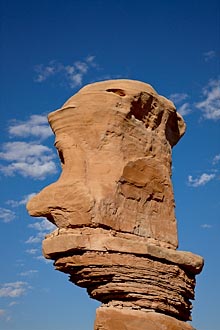 We continued heading south on the Notom-Bullfrog Road and we stopped to photograph some rock pillars that are outside the park. One of them reminded me of a head (left).
We re-entered the park and the road got closer to the rock formations of the reef. We stopped to photograph occasionally even though the sun was high in the sky. Instead of turning around, we decided to continue the loop all the way to Boulder. The area around the Burr Trail Switchbacks was fantastic! The road goes up the steep face of the reef in a series of switchbacks, and the views are spectacular. After reaching the top, the road flattens out again and it becomes paved in Grand Staircase/Escalante National Monument. The Burr Trail Road goes by some wonderful salmon-colored cliffs that reminded me of Zion National Park. We would like to return to the area to spend more time between Boulder and the southern end of Capitol Reef National Park. We didn't stop to photograph because it was getting quite late and we were ready for lunch.
We went to the Boulder Mesa Restaurant in Boulder around 1:30 for lunch, and the place was still quite busy. I ordered a Pastrami Melt with potato salad, and J ordered a BLT with fries. We both went online through a slow National Access signal while waiting for our food to arrive. The food was good and J loved her BLT that came with avocado on it. We left around 2:35.
J called the Capitol Reef National Park hotline to check road conditions, and they said that the ford across the Fremont River was impassable and that the Caineville Wash Road, the other way to get to Cathedral Valley, was washed out, so it doesn't look like we'll be able to get to Cathedral Valley any time soon
We went to the parking lot of a hotel in Torrey around 3:25 to use their open Wi-Fi network because the internet back in Boulder wasn't good enough for us to get much accomplished. I was able to upload some more images to my stock agent and I worked up a blog entry. We left around 4:45.
We filled up the Jeep at the Phillips 66 in Torrey at $3.299/gal — can you say expensive?! We left around 4:55.
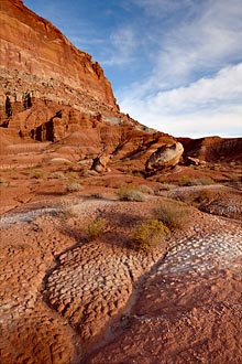
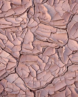 We entered Capitol Reef National Park and stopped to photograph along the main road. I tried to capture the various layers near the road in the image to the far left. The red Wingate Sandstone near the top fractures in near-vertical faces and creates debris slopes below against the also red Moenkopi Sandstone and the flat valleys are covered with a sandy/muddy mixture of the Chinle Formation that develops small mounds. The image was created from three captures to maintain detail in the bright sky and dark foreground that were combined by hand in Photoshop. On the way back to the Jeep, I stopped to photograph the neat patterns in some cracked ground (near left).
On the way back to the RV, we stopped to explore Fremont Falls. There was quite a lot of muddy water going over the falls from the recent rains, and the river goes through some nice rock channels just upstream of the falls.
We returned to the RV around 6:15 after a long day.
After I showered, I had dinner of two leftover franks, a banana, and an apple while J showered.
J started to watch the movie Temple Grandin on DVD about an autistic professor at CSU (Colorado State University) while I downselected the images I took today. J made some popcorn around 7:50 to eat for dinner while watching the rest of the movie. I watched the last 15 minutes or so of the movie then processed four images for the blog before going to bed.
We got up earlier than usual all excited to go explore the Cathedral Valley area in the northern part of Capitol Reef National Park. I made a mug of coffee to go and J started a mug of tea steeping, and we left in the Jeep around 7:05 before the approximately 7:35 official sunrise.
I had Clif Bars for breakfast while driving.
We went to the ford across the Fremont River, and the ground looked really muddy before we even got close enough to the river to see it. Neither of us wanted to get stuck, so we turned around and took the Notom-Bullfrog Road south along the eastern side of the park instead.
Morning Cloud
Capitol Reef National Park, Utah, USA
Canon EOS 1Ds Mk III, 24-105 (at 32mm),
1/250 sec, f8, ISO 100
1/250 sec, f8, ISO 100
Head Rock
Garfield County, Utah, USA
Canon EOS 1Ds Mk III, 24-105 (at 60mm),
1/180 sec, f11, ISO 100
1/180 sec, f11, ISO 100
We re-entered the park and the road got closer to the rock formations of the reef. We stopped to photograph occasionally even though the sun was high in the sky. Instead of turning around, we decided to continue the loop all the way to Boulder. The area around the Burr Trail Switchbacks was fantastic! The road goes up the steep face of the reef in a series of switchbacks, and the views are spectacular. After reaching the top, the road flattens out again and it becomes paved in Grand Staircase/Escalante National Monument. The Burr Trail Road goes by some wonderful salmon-colored cliffs that reminded me of Zion National Park. We would like to return to the area to spend more time between Boulder and the southern end of Capitol Reef National Park. We didn't stop to photograph because it was getting quite late and we were ready for lunch.
We went to the Boulder Mesa Restaurant in Boulder around 1:30 for lunch, and the place was still quite busy. I ordered a Pastrami Melt with potato salad, and J ordered a BLT with fries. We both went online through a slow National Access signal while waiting for our food to arrive. The food was good and J loved her BLT that came with avocado on it. We left around 2:35.
J called the Capitol Reef National Park hotline to check road conditions, and they said that the ford across the Fremont River was impassable and that the Caineville Wash Road, the other way to get to Cathedral Valley, was washed out, so it doesn't look like we'll be able to get to Cathedral Valley any time soon
We went to the parking lot of a hotel in Torrey around 3:25 to use their open Wi-Fi network because the internet back in Boulder wasn't good enough for us to get much accomplished. I was able to upload some more images to my stock agent and I worked up a blog entry. We left around 4:45.
We filled up the Jeep at the Phillips 66 in Torrey at $3.299/gal — can you say expensive?! We left around 4:55.
Erosion Layers
Capitol Reef National Park, Utah, USA
Canon EOS 1Ds Mk III, 24 TS II,
1/45, 1/30, & 1/15 sec, f11, ISO 100
1/45, 1/30, & 1/15 sec, f11, ISO 100
Cracked Ground
Capitol Reef National Park, Utah, USA
Canon EOS 1Ds Mk III, 90 TS,
1/8 sec, f11, ISO 100
1/8 sec, f11, ISO 100
On the way back to the RV, we stopped to explore Fremont Falls. There was quite a lot of muddy water going over the falls from the recent rains, and the river goes through some nice rock channels just upstream of the falls.
We returned to the RV around 6:15 after a long day.
After I showered, I had dinner of two leftover franks, a banana, and an apple while J showered.
J started to watch the movie Temple Grandin on DVD about an autistic professor at CSU (Colorado State University) while I downselected the images I took today. J made some popcorn around 7:50 to eat for dinner while watching the rest of the movie. I watched the last 15 minutes or so of the movie then processed four images for the blog before going to bed.