
Thank you for visiting RV Ramblings, the daily happenings of full-time RVers, James and J, as told by James.
You may share this particular blog entry by referring to www.rvramblings.com/?date=2010-05-19.
Visit www.rvramblings.com to view the latest blog entry. Click here to create a bookmark that will take you to the latest blog entry.
May 19, 2010, a Wednesday
near Canyonlands National Park Needles District to near Moab, Utah, USA
— Photographed in the Needles District of Canyonlands National Park
[You may view a map of Canyonlands National Park in PDF format and map of Arches National Park in PDF format.]
The wind was dead calm when we got up. There weren't any clouds over near the Sixshooter peaks, which is where we thought we might go this morning, and there were some clouds over the Needles District of Canyonlands National Park, so we decided to go there instead. I made some instant coffee to go and J started a mug of tea steeping. We left in the Jeep around 7:00.
I had Clif Bars for breakfast while driving.
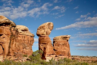 We entered the Needles District of Canyonlands National Park and took the 4WD road towards the Colorado River Overlook. There are some nice rock formations along the road not too far from the Visitor Center, and the clouds behind some of them were really nice (left). We stopped about where I had stopped on my previous visit, but this time we stopped because we got stuck! As I was driving down over a rock step, the right-front and left-rear wheels both became lightly loaded and could no longer provide enough traction to get the right-rear wheel over a small lip. We found some small rocks to put under the loose wheels, and I was able to get the Jeep free. On our way back, J compared it to skiing. One time, she heard someone say that she had been out skiing and she hadn't fallen down all day long. J was surprised because if you're pushing your limits, you're likely to take a fall. So, I guess you can say we were pushing our limits today, and we survived to tell the tale.
 Shortly after turning around, we stopped to photograph Lavender Evening-Primrose, Dwarf Lupine, and Sweetroot Spring-Parsley.
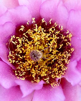
Further on our way back, J spotted some Whipple's Fishhook cacti. We stopped, and it turned out to be the mother lode! There must have been 25-30 plants in the small area, and we had a blast photographing them. My favorite image is of just the center part of the bloom taken from directly overhead inline with the pistil (left).
After we exited the park on our way "home," we could see some nice clouds over the Sixshooter peaks and wondered if we should have gone there instead.
We returned to the RV around 12:35 and I had a Clif Bar while prepping the RV to move. We left our site with me in the RV and J following in the Jeep, then stopped to hook up the Jeep to tow at a convenient location. We got underway around 1:10.
I had two more Clif Bars to round out lunch while driving. Then I listened to an episode of Car Talk. We got on US-191 heading north around 1:50.
We stopped at Quality RV in Moab around 2:35 to dump and take on fresh water. J went online through an open WiFi network. We left around 3:10.
We went to the City Market (grocery store) in Moab and I filled up the Jeep at $2.969/gal while J started grocery shopping. I went in and picked up some ham, cheese, apples, and bananas, then left so J could continue going up and down all of the aisles. I went out to the RV and went online through the fast Verizon Broadband signal. We left around 4:15.
We headed towards our favorite boondocking spot near Moab, and we were glad that no one else had moved in while we were gone.
We had dinner at 5:20 of Bertolli Chicken Florentine & Farfalle.
We left in the Jeep at 6:10.
We entered Arches National Park and took the dirt road through Salt Valley towards the Klondike Bluffs and Tower Arch. (You may view a map of Arches National Park in PDF format.) The road was very washboardy — yuck! We turned onto the 4WD road to take us very close to Tower Arch, but turned around before trying to go over the difficult bare rock section — one "fall" per day is good enough for us. :) Instead, we went to the regular Klondike Bluffs trailhead and briefly contemplated taking the 1.2-mile (2km) hike out to Tower Arch. Because it was about 7:20 and sunset was to be at 8:27, that wouldn't give us much time to photograph and I didn't want to hike back in the dark — the trail near the trailhead is steep and indistinct. So, we left and headed back the washboardy road.
By the time we returned to the paved road, most of the clouds had moved far to the east and were no longer that interesting for photography. J photographed some fins with the snow-covered La Sal Mountains and some clouds in the background.
We returned to the RV around 9:15. I downloaded the images from this morning and started to downselect them.
The wind was dead calm when we got up. There weren't any clouds over near the Sixshooter peaks, which is where we thought we might go this morning, and there were some clouds over the Needles District of Canyonlands National Park, so we decided to go there instead. I made some instant coffee to go and J started a mug of tea steeping. We left in the Jeep around 7:00.
I had Clif Bars for breakfast while driving.
Rock Formation And Clouds
Canyonlands National Park
Needles District, Utah, USA
Needles District, Utah, USA
Canon EOS 1Ds Mk III, 24-105 (at 55mm), polarizer,
1/125 sec, f8, ISO 100
1/125 sec, f8, ISO 100
Whipple's Fishhook Bloom
Canyonlands National Park
Needles District, Utah, USA
Needles District, Utah, USA
Canon EOS 1Ds Mk III, 180 Macro,
1/6 sec, f16, ISO 160
1/6 sec, f16, ISO 160
Further on our way back, J spotted some Whipple's Fishhook cacti. We stopped, and it turned out to be the mother lode! There must have been 25-30 plants in the small area, and we had a blast photographing them. My favorite image is of just the center part of the bloom taken from directly overhead inline with the pistil (left).
After we exited the park on our way "home," we could see some nice clouds over the Sixshooter peaks and wondered if we should have gone there instead.
We returned to the RV around 12:35 and I had a Clif Bar while prepping the RV to move. We left our site with me in the RV and J following in the Jeep, then stopped to hook up the Jeep to tow at a convenient location. We got underway around 1:10.
I had two more Clif Bars to round out lunch while driving. Then I listened to an episode of Car Talk. We got on US-191 heading north around 1:50.
We stopped at Quality RV in Moab around 2:35 to dump and take on fresh water. J went online through an open WiFi network. We left around 3:10.
We went to the City Market (grocery store) in Moab and I filled up the Jeep at $2.969/gal while J started grocery shopping. I went in and picked up some ham, cheese, apples, and bananas, then left so J could continue going up and down all of the aisles. I went out to the RV and went online through the fast Verizon Broadband signal. We left around 4:15.
We headed towards our favorite boondocking spot near Moab, and we were glad that no one else had moved in while we were gone.
We had dinner at 5:20 of Bertolli Chicken Florentine & Farfalle.
We left in the Jeep at 6:10.
We entered Arches National Park and took the dirt road through Salt Valley towards the Klondike Bluffs and Tower Arch. (You may view a map of Arches National Park in PDF format.) The road was very washboardy — yuck! We turned onto the 4WD road to take us very close to Tower Arch, but turned around before trying to go over the difficult bare rock section — one "fall" per day is good enough for us. :) Instead, we went to the regular Klondike Bluffs trailhead and briefly contemplated taking the 1.2-mile (2km) hike out to Tower Arch. Because it was about 7:20 and sunset was to be at 8:27, that wouldn't give us much time to photograph and I didn't want to hike back in the dark — the trail near the trailhead is steep and indistinct. So, we left and headed back the washboardy road.
By the time we returned to the paved road, most of the clouds had moved far to the east and were no longer that interesting for photography. J photographed some fins with the snow-covered La Sal Mountains and some clouds in the background.
We returned to the RV around 9:15. I downloaded the images from this morning and started to downselect them.